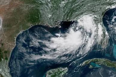
Here is the current situation and forecasted path according to the National Hurricane Center (NHC):
Current Status & Location
- Position: Located in the northern Gulf of Mexico, roughly 90 miles south-southwest of Panama City, Florida, and 125 miles southeast of Mobile, Alabama.
- Winds: Maximum sustained winds have reached 60 mph with stronger gusts.
- Movement: Moving slowly west-northwest at around 5 mph.
Key Hazards & Warnings
| Hazard | Expected Impact | Affected Regions |
| Heavy Rainfall | 2–4 inches widespread, with isolated areas up to 6–8 inches. | Florida Panhandle, coastal Alabama, Mississippi, Louisiana, extending toward middle Texas. |
| Storm Surge | Inundation of 1 to 4 feet above ground level along the immediate coastline. | From the Florida Panhandle through coastal Alabama, Mississippi, and southeastern Louisiana. |
| Severe Weather | Isolated waterspouts and brief tornadoes. | Florida Big Bend region and adjacent coastal waters. |
Active Watches & Warnings
- Tropical Storm Warning: Issued for coastal areas from the Florida–Alabama border westward to Terrebonne-Lafourche Parish line in Louisiana.
- Tropical Storm Watch: In effect for the Florida Panhandle as well as the New Orleans metro area.
- Storm Surge Watch: Covers the coast from the Florida–Alabama border westward to the mouth of the Mississippi River.
Forecast Note: Due to weak steering currents, Bertha is drifting slowly and erratically. While strong wind shear and dry air are expected to limit significant intensification, its slow pace prolongs the threat of heavy rain, high surf, and coastal flooding through the middle of the week.
(Visited 15 times, 1 visits today)